Plot of Land
The plot of land is a key entity in the EUDR Risk Assessment and Mitigation. Each product must ensure that the plot of land where it was produced was not the result of deforestation or forest degradation as well as the geolocation is in accordance with the region-specific legislation (specifically, not in the area of Indigenous people or protected areas).
Open Atlas Vantage-X product provides an API to validate and organise information about plots of land. The plot of land could then be used to run a risk assessment.
Terminology overview
The plot of land is defined in the EUDR Article 2:
(27) ‘plot of land’ means land within a single real-estate property, as recognised by the law of the country of production, which enjoys sufficiently homogeneous conditions to allow an evaluation of the aggregate level of risk of deforestation and forest degradation associated with relevant commodities produced on that land;
The plot of land is defined by its geolocation. The term is defined as:
(28) ‘geolocation’ means the geographical location of a plot of land described by means of latitude and longitude coordinates corresponding to at least one latitude and one longitude point and using at least six decimal digits; for plots of land of more than four hectares used for the production of the relevant commodities other than cattle, this shall be provided using polygons with sufficient latitude and longitude points to describe the perimeter of each plot of land;
Geometry Types
Based on the definition of the geolocation, we can identify two geometry types that describe the plot of land:
- Polygon geometry for a plot of land larger than 4 hectares;
- Point or polygon geometry for a plot of land smaller than 4 hectares.
Geometry types are defined by the OpenGIS Simple Features Implementation Specification for SQL:
A Point is a 0-dimensional geometry and represents a single location in coordinate space. A Point has a x-coordinate value and a y-coordinate value.
A Polygon is a planar Surface, defined by 1 exterior boundary and 0 or more interior boundaries. Each interior boundary defines a hole in the Polygon.
Open Atlas Vantage-X product uses the GeoJSON geometry object specification to describe geometry. GeoJSON is one of the geospatial data formats. It is the data format that is designed to be used by the EU Information System to declare the performed due diligence.
Small Plots Registration
When registering plots smaller than 4 hectares, you can use polygon or point geometry.
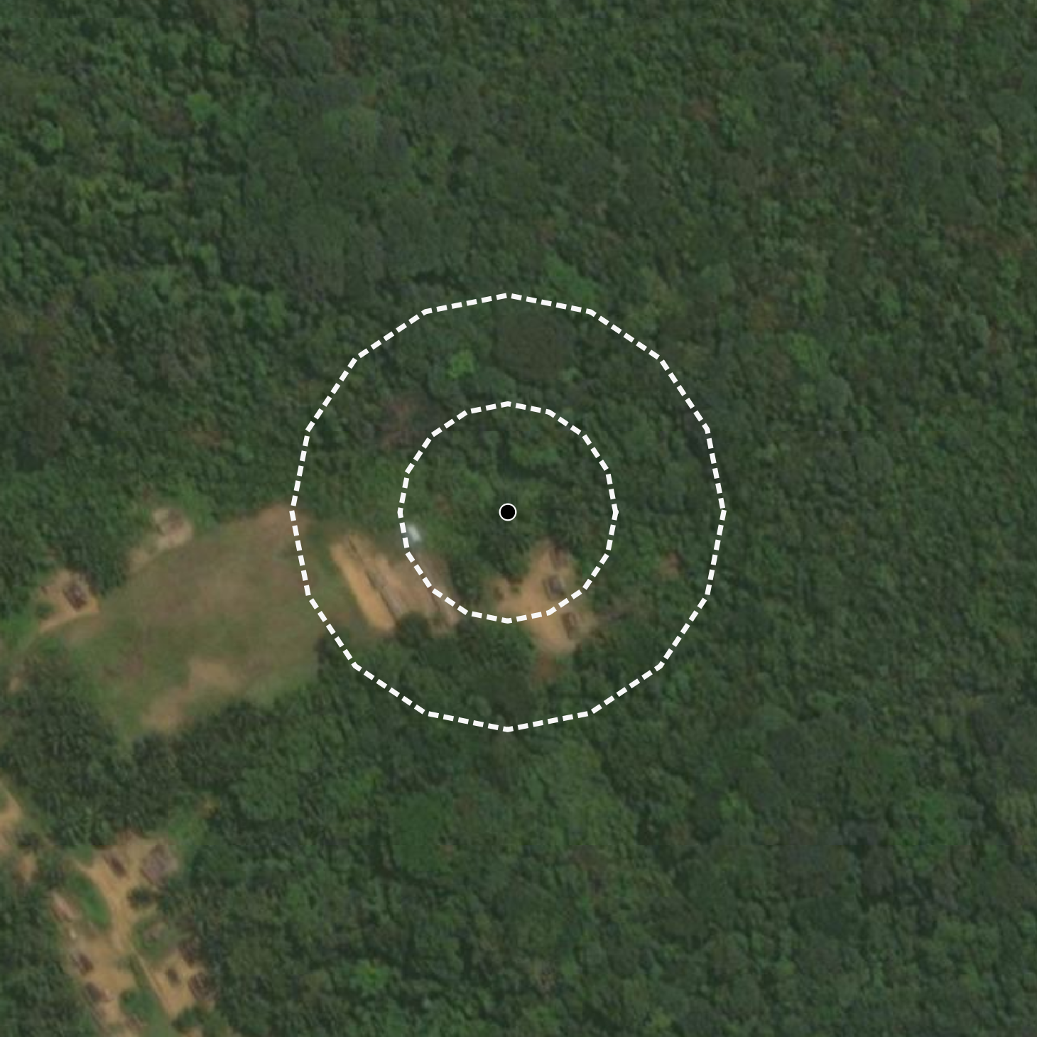
When point geometry is provided, Vantage-X will build a circle around the provided geometry. By default, the area of a built circle is approximately 4 hectares. Often, farm plots are smaller than 4 hectares, so Vantage-X supports dynamic buffer creation. While registering the plot, you can provide the area value of the plot in hectares in the point_ha parameter and the system will create a circle that represents the provided value.
The generated circle is sized to the area you send in point_ha, so a value like 1.5 produces a circle a little over 1.5 hectares. Analysis tokens are rounded up to the next whole number, which means that example would reserve 2 tokens for the run.
Plots Examples
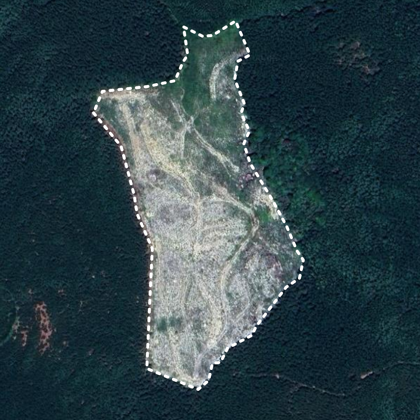
Example of the Polygon Geometry - Vietnam |
Example of Point Geometry and Registered Plots (0.5ha and 2ha) - DR Congo |
Geometry Validity
Producing geometry data often comes with a set of issues. Some of the issues are defined as invalid geometries; others could be valid, but problematic to process by some of the tools. Vantage-X runs the geometry validator when you register a plot.
For a more detailed overview of the official EUDR GeoJSON requirements (geometry types, errors, and handling), please see the EUDR GeoJSON Requirements page.
Validation Checks at This Step
The following geometries are not accepted. The API returns an error with the details specified:
- Invalid Specification: Geometries with fewer than three unique nodes or that are not a closed Polygon.
- Problematic Geometries: Self-intersecting geometries (large or small) or unclosed polygons.
- Business Rules for EUDR Compliance: Other than Polygon geometry type or polygons that are are excessively elongated (often occurs when incorrect symbols or values are used in coordinate inputs, resulting in unrealistic geometries).
Supported Geometries
Please note that while some geometries may have formatting issues, they are still accepted:
- Technically Invalid Geometries: These include cases where the exterior ring is not counter-clockwise, the interior ring is not clockwise, or inner and exterior rings intersect or cross.
- Problematic Geometries: This includes polygons with duplicate nodes, multiple holes or with the third dimension, which are supported. The third dimension component is ignored.
Plot of Land Properties
While registering a plot of land, you can provide additional information in addition to the geometry. This includes the commodity and the harvest_date, but both are now optional at registration time.
commodityrepresents an EUDR in-scope commodity. Vantage-X supports the following commodity values:wood,soy,cocoa,coffee,palm_oil,beef,rubber.harvest_datecaptures the production date required by EUDR. It is a single ISO-8601 date.
If you skip these fields during plot creation, you can still send them later when you create an analysis job. When neither the plot nor the job payload provides a harvest date, the current date is used for that analysis run. Commodity must be set either on the plot or on the job payload before an analysis can start.
The plot of land supports other properties that help better data organisation, including: plot_name, notes, phone and owner.